
Aichwald topographic map
Click on the map to display elevation.
About this map
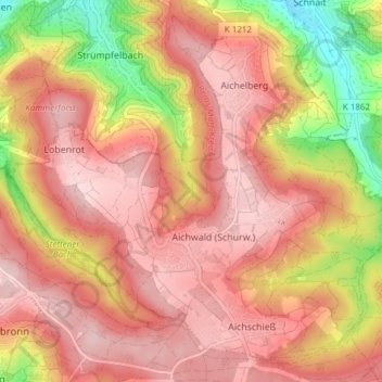
Name: Aichwald topographic map, elevation, terrain.
Location: Aichwald, Landkreis Esslingen, Baden-Württemberg, 73773, Germany (48.74372 9.34395 48.78827 9.41975)
Average elevation: 399 m
Minimum elevation: 248 m
Maximum elevation: 482 m
Other topographic maps
Click on a map to view its topography, its elevation and its terrain.
Ruine Reußenstein
Germany > Baden-Württemberg > Landkreis Esslingen > Neidlingen
Average elevation: 675 m