Geolocate

Montecerboli topographic map

Click on the map to display elevation.

About this map

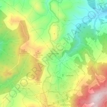
Name: Montecerboli topographic map, elevation, terrain.

Location: Montecerboli, Pomarance, Pisa, Tuscany, 56041, Italy (43.22822 10.85979 43.26822 10.89979)

Average elevation: 410 m

Minimum elevation: 194 m

Maximum elevation: 681 m

Gear up for your next adventure:

🧥Waterproof Hiking Jacket - Protect yourself from rain and wind while hiking
👟Trail Running Shoes - Agile footwear for fast-paced topographic exploration
🦌Outdoor Trail Camera - Monitor wildlife activity near your favorite spots
🍽️Titanium Camping Spork - Ultralight and indestructible eating utensil
🎒Backpack Rain Cover - External shield to keep your entire pack dry

As an Amazon Associate, this site earns from qualifying purchases at no extra cost to you.