Geolocate

Isabang topographic map

Click on the map to display elevation.

About this map

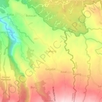
Name: Isabang topographic map, elevation, terrain.

Location: Isabang, Majayjay, Laguna, Calabarzon, 4005, Philippines (14.12139 121.48760 14.16139 121.52760)

Average elevation: 384 m

Minimum elevation: 207 m

Maximum elevation: 523 m

Other topographic maps

Click on a map to view its topography, its elevation and its terrain.

Malinao River

Philippines > Laguna > Majayjay > Rizal

Average elevation: 391 m

Gear up for your next adventure:

🧥Waterproof Pants - Keep dry during rainy hiking conditions
💡LED Headlamp - Hands-free illumination for night hiking and camping
🔦LED Flashlight - Powerful and long-lasting flashlight for camping and emergencies
🥾Mountain Hiking Boots - High-traction boots for rocky terrain
🦟Insect Repellent - Keep mosquitoes and black flies away in wooded areas

As an Amazon Associate, this site earns from qualifying purchases at no extra cost to you.