Geolocate

Confrides topographic map

Click on the map to display elevation.

About this map

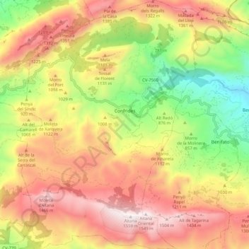
Name: Confrides topographic map, elevation, terrain.

Location: Confrides, la Marina Baixa, Alacant / Alicante, Valencian Community, Spain (38.63904 -0.31271 38.71850 -0.23854)

Average elevation: 998 m

Minimum elevation: 396 m

Maximum elevation: 1,551 m

Other topographic maps

Click on a map to view its topography, its elevation and its terrain.

Cap Negre

Spain > Valencian Community > Xàbia / Jávea

Average elevation: 40 m

Pedralba

Spain > Valencian Community > La Serranía > Pedralba

Average elevation: 177 m

Gear up for your next adventure:

🧭GPS Outdoor Watch - Smart watch for navigation and fitness tracking in nature
🪜Heavy Duty Carabiners - Multi-use clips for securing gear to your backpack
🚲Handlebar Phone Mount - View topographic-map.com live while cycling
🥾Waterproof Trail Shoes - Shoes designed to handle wet terrain
🥾Mountain Hiking Shoes - Shoes with superior grip for mountainous terrain

As an Amazon Associate, this site earns from qualifying purchases at no extra cost to you.