Geolocate

Dithmarschen topographic map

Click on the map to display elevation.

About this map

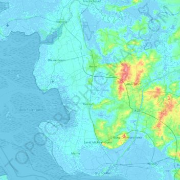
Name: Dithmarschen topographic map, elevation, terrain.

Location: Dithmarschen, Schleswig-Holstein, Germany (53.87754 8.67970 54.37878 9.44437)

Average elevation: 5 m

Minimum elevation: -5 m

Maximum elevation: 76 m

Other topographic maps

Click on a map to view its topography, its elevation and its terrain.

Kiel

Germany > Schleswig-Holstein > Kiel

Average elevation: 24 m

Flensburg

Germany > Schleswig-Holstein > Flensburg

Average elevation: 39 m

Lübeck

Germany > Schleswig-Holstein > Lübeck

Average elevation: 29 m

Hüxwiese

Germany > Schleswig-Holstein > Lübeck

Average elevation: 11 m

Pinneberg

Germany > Schleswig-Holstein

Average elevation: 23 m

Heidkate

Germany > Schleswig-Holstein > Kreis Plön > Wisch

Average elevation: -1 m

Stemwarde

Germany > Schleswig-Holstein > Stormarn > Barsbüttel

Average elevation: 48 m

Knust

Germany > Schleswig-Holstein > Kreis Pinneberg > Quickborn

Average elevation: 14 m

Enge

Germany > Schleswig-Holstein > Enge

Average elevation: 10 m

Wilstedt

Germany > Schleswig-Holstein > Stormarn > Wilstedt

Average elevation: 32 m

Klumpen

Germany > Schleswig-Holstein > Dithmarschen > Pahlen

Average elevation: 6 m

Pinneberg

Germany > Schleswig-Holstein

Average elevation: 23 m

Scheidekate

Germany > Schleswig-Holstein > Stormarn > Elmenhorst

Average elevation: 40 m

Gear up for your next adventure:

🥾Waterproof Hiking Boots - Boots keeping your feet dry in wet conditions
🛌Down Sleeping Bag - Superior warmth-to-weight ratio for cold nights
🧥Waterproof Hiking Jacket - Protect yourself from rain and wind while hiking
💧Reusable Water Bottle - Durable water bottles for hydration on trails
💧Hydration Bladder - Hands-free hydration solution for long treks

As an Amazon Associate, this site earns from qualifying purchases at no extra cost to you.