Geolocate

Matutinao topographic map

Click on the map to display elevation.

About this map

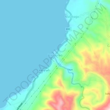
Name: Matutinao topographic map, elevation, terrain.

Location: Matutinao, Badian, Cebu, Central Visayas, Philippines (9.79104 123.34768 9.83104 123.38768)

Average elevation: 77 m

Minimum elevation: 0 m

Maximum elevation: 365 m

Gear up for your next adventure:

🚲Bike Repair Kit - Essential tools for on-trail mechanical issues
🥾Waterproof Hiking Boots - Essential footwear for rugged terrain and wet Canadian trails
💡Solar Camping Lamp - Eco-friendly lighting for campsites
👟Leg Gaiters - Keep debris, mud, and snow out of your boots
🔭Compact Monocular - One-handed bird watching and trail spotting

As an Amazon Associate, this site earns from qualifying purchases at no extra cost to you.