
Mount Carmel Center topographic map
Click on the map to display elevation.
About this map
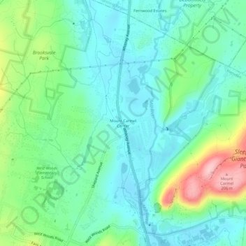
Name: Mount Carmel Center topographic map, elevation, terrain.
Average elevation: 79 m
Minimum elevation: 29 m
Maximum elevation: 215 m
Other topographic maps
Click on a map to view its topography, its elevation and its terrain.
Lake Whitney
United States > Connecticut > South Central Connecticut Planning Region > Hamden > Whitneyville
Average elevation: 25 m
Sleeping Giant State Park
United States > Connecticut > South Central Connecticut Planning Region > Hamden
Sleeping Giant (also known as the Blue Hills and Mount Carmel), (Hobbomock in Quinnipiac), is a rugged traprock mountain with a high point of 739 feet (225 m), located eight miles (13 km) north of New Haven, Connecticut. A prominent landscape feature visible for miles, the Sleeping Giant receives its name from…
Average elevation: 79 m
Lake Whitney
United States > Connecticut > South Central Connecticut Planning Region > Hamden
Average elevation: 25 m