Geolocate

Kendall topographic map

Click on the map to display elevation.

About this map

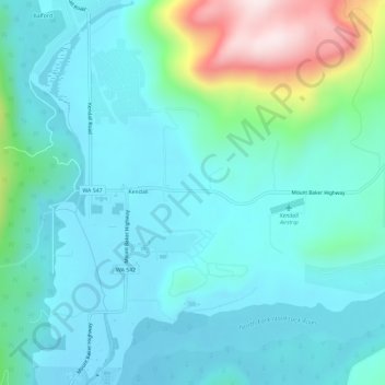
Name: Kendall topographic map, elevation, terrain.

Location: Kendall, Whatcom County, Washington, United States (48.89782 -122.15453 48.93608 -122.11051)

Average elevation: 214 m

Minimum elevation: 120 m

Maximum elevation: 620 m

Other topographic maps

Click on a map to view its topography, its elevation and its terrain.

Gear up for your next adventure:

🧰Emergency Multi-Tool - Compact multi-tool for outdoor survival
🧴Waterproofing Spray - Restore the DWR coating on jackets and tents
🧤Rechargeable Heated Gloves - Extreme warmth for Canadian winter expeditions
🎒Fully Waterproof Backpack - Total protection for photography gear and electronics
🦟Insect Repellent - Keep mosquitoes and black flies away in wooded areas

As an Amazon Associate, this site earns from qualifying purchases at no extra cost to you.