Geolocate

Pageruyung topographic map

Click on the map to display elevation.

About this map

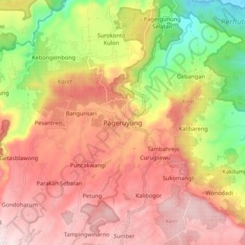
Name: Pageruyung topographic map, elevation, terrain.

Location: Pageruyung, Kendal, Central Java, Java, Indonesia (-7.08373 110.00291 -7.00373 110.08291)

Average elevation: 370 m

Minimum elevation: 29 m

Maximum elevation: 619 m

Gear up for your next adventure:

🎒Hiking Backpack - Lightweight and ergonomic backpacks for day hikes or multi-day treks
🧥Ultralight Puffy Jacket - Maximum warmth that packs down to the size of an orange
🧥Softshell Hiking Jacket - The perfect balance of wind protection and breathability
💧Collapsible Water Bottle - Space-saving water bottle for outdoor activities
🥾Hiking Leggings - Comfortable leggings for outdoor activities

As an Amazon Associate, this site earns from qualifying purchases at no extra cost to you.