Geolocate

Luc (Ayent) topographic map

Click on the map to display elevation.

About this map

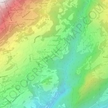
Name: Luc (Ayent) topographic map, elevation, terrain.

Location: Luc (Ayent), Ayent, Hérens, Wallis, 1966, Switzerland (46.26272 7.39781 46.30272 7.43781)

Average elevation: 1,057 m

Minimum elevation: 529 m

Maximum elevation: 1,945 m

Gear up for your next adventure:

🧥Thermal Layer - Insulating layer for cold outdoor conditions
🕶️Polarized Sunglasses - Protect your eyes with durable polarized lenses
🚲Bike Repair Kit - Essential tools for on-trail mechanical issues
🛌Down Sleeping Bag - Superior warmth-to-weight ratio for cold nights
Camping Tent - Weather-resistant tents suitable for 2 to 6 people

As an Amazon Associate, this site earns from qualifying purchases at no extra cost to you.