Geolocate

Panjar topographic map

Click on the map to display elevation.

About this map

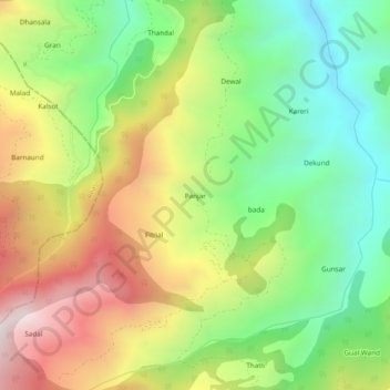
Name: Panjar topographic map, elevation, terrain.

Location: Panjar, Udhampur, Jammu and Kashmir, India (33.04461 75.07411 33.08461 75.11411)

Average elevation: 1,414 m

Minimum elevation: 933 m

Maximum elevation: 2,058 m

Gear up for your next adventure:

🛶Waterproof Dry Bags - Keep electronics and clothes dry during river crossings
💧Filtered Water Bottle - Safe drinking water on the go
🥾Mountaineering Boots - Supportive boots for climbing and high-altitude hiking
🧥Insulated Jacket - Keep warm in cold outdoor conditions
🥾Hiking Shorts - Breathable shorts suitable for summer hikes

As an Amazon Associate, this site earns from qualifying purchases at no extra cost to you.