Geolocate

Hirakud topographic map

Click on the map to display elevation.

About this map

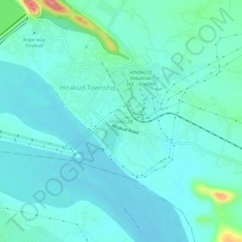
Name: Hirakud topographic map, elevation, terrain.

Location: Hirakud, Sambalpur, Odisha, 768016, India (21.50568 83.88370 21.54568 83.92370)

Average elevation: 163 m

Minimum elevation: 143 m

Maximum elevation: 267 m

Other topographic maps

Click on a map to view its topography, its elevation and its terrain.

Hirakud Dam

India > Odisha > Hirakud

Average elevation: 178 m

Hirakud

India > Odisha > Hirakud

Average elevation: 181 m

Hirakud Dam

India > Odisha > Hirakud

Average elevation: 178 m

Gear up for your next adventure:

🔪Outdoor Multitool - Versatile tool for repairs and food prep in the wild
🥾Waterproof Trail Shoes - Shoes designed to handle wet terrain
🧦Crew Hiking Socks - Comfortable socks for long-distance hikes
👟Trail Running Shoes - Agile footwear for fast-paced topographic exploration
🛁Quick-Dry Microfiber Towel - Space-saving towel that dries rapidly on the move

As an Amazon Associate, this site earns from qualifying purchases at no extra cost to you.