
Make a donation
Gear up for your next adventure:
As an Amazon Associate, this site earns from qualifying purchases at no extra cost to you.
Gündlischwand topographic map
Click on the map to display elevation.
Make a donation
Gear up for your next adventure:
As an Amazon Associate, this site earns from qualifying purchases at no extra cost to you.
About this map
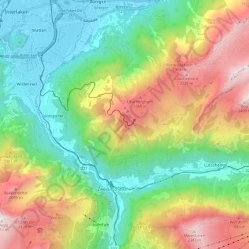
Name: Gündlischwand topographic map, elevation, terrain.
Average elevation: 1,268 m
Minimum elevation: 561 m
Maximum elevation: 2,417 m
Make a donation
Gear up for your next adventure:
As an Amazon Associate, this site earns from qualifying purchases at no extra cost to you.
Other topographic maps
Click on a map to view its topography, its elevation and its terrain.
Titlis
Switzerland > Bern > Interlaken-Oberhasli administrative district > Innertkirchen
Average elevation: 2,520 m
Schilthorn
Switzerland > Bern > Interlaken-Oberhasli administrative district > Lauterbrunnen
Average elevation: 2,455 m
Burglauenen
Switzerland > Bern > Interlaken-Oberhasli administrative district > Grindelwald
Average elevation: 1,407 m
Brienz
Switzerland > Bern > Interlaken-Oberhasli administrative district > Brienz (BE)
Average elevation: 810 m
Make a donation
Gear up for your next adventure:
As an Amazon Associate, this site earns from qualifying purchases at no extra cost to you.
Ballenberg
Switzerland > Bern > Interlaken-Oberhasli administrative district > Hofstetten bei Brienz > Hofstetten
Average elevation: 774 m
Wellhorn
Switzerland > Bern > Interlaken-Oberhasli administrative district > Schattenhalb
Average elevation: 2,486 m