
Make a donation
Gear up for your next adventure:
As an Amazon Associate, this site earns from qualifying purchases at no extra cost to you.
Lac du Portillon topographic map
Click on the map to display elevation.
Make a donation
Gear up for your next adventure:
As an Amazon Associate, this site earns from qualifying purchases at no extra cost to you.
Lac du Portillon
Situé près de la crête frontalière avec l'Espagne, au pied du pic Perdiguère à une altitude de 2 580 m près de Bagnères-de-Luchon en région Occitanie. Il collecte les eaux de la fonte des neiges et des torrents environnants issus du Seil de la Baque et du glacier du Portillon d'Oô.
Make a donation
Gear up for your next adventure:
As an Amazon Associate, this site earns from qualifying purchases at no extra cost to you.
About this map
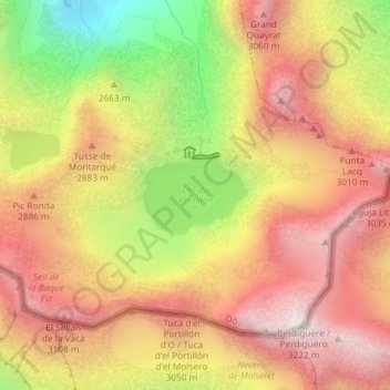
Name: Lac du Portillon topographic map, elevation, terrain.
Average elevation: 2,752 m
Minimum elevation: 2,104 m
Maximum elevation: 3,208 m
Make a donation
Gear up for your next adventure:
As an Amazon Associate, this site earns from qualifying purchases at no extra cost to you.