Geolocate

Pizzo topographic map

Click on the map to display elevation.

About this map

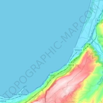
Name: Pizzo topographic map, elevation, terrain.

Location: Pizzo, Vibo Valentia, Calabria, Italy (38.70702 16.14691 38.81239 16.23188)

Average elevation: 64 m

Minimum elevation: -1 m

Maximum elevation: 436 m

Other topographic maps

Click on a map to view its topography, its elevation and its terrain.

Caroniti

Italy > Calabria > Vibo Valentia > Joppolo

Average elevation: 419 m

Punta Safò

Italy > Calabria > Vibo Valentia > Briatico

Average elevation: 15 m

Arzona

Italy > Calabria > Vibo Valentia

Average elevation: 450 m

Gear up for your next adventure:

🔦UV Flashlight - Detect minerals or specific insects in the dark
🧤Thermal Hiking Gloves - Grip-enhanced gloves for cold-weather altitude trekking
🥾Trail Running Shoes - Lightweight and durable shoes for trail running
🐕Hiking Dog Pack - Let your canine companion carry their own water and food
🏃Hydration Running Vest - Carry water and maps close to your body for speed

As an Amazon Associate, this site earns from qualifying purchases at no extra cost to you.