Geolocate

Elko topographic map

Click on the map to display elevation.

About this map

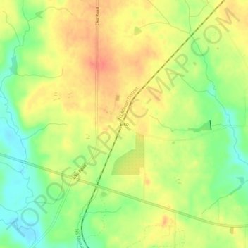
Name: Elko topographic map, elevation, terrain.

Location: Elko, Houston County, Georgia, 31025, United States (32.31121 -83.72617 32.35121 -83.68617)

Average elevation: 123 m

Minimum elevation: 96 m

Maximum elevation: 145 m

Other topographic maps

Click on a map to view its topography, its elevation and its terrain.

Warner Robins

United States > Georgia > Houston County

Average elevation: 101 m

Perry

United States > Georgia > Houston County

Average elevation: 111 m

Warner Robins

United States > Georgia > Houston County

Average elevation: 101 m

Lake Joy

United States > Georgia > Houston County

Average elevation: 105 m

Perry

United States > Georgia > Houston County

Average elevation: 111 m

Gear up for your next adventure:

🎒Hiking Daypack - Lightweight and durable backpacks for day trips and excursions
🥽Outdoor Goggles - Protective eyewear for outdoor activities
🥾Waterproof Trail Shoes - Shoes designed to handle wet terrain
🧭GPS Handheld Device - Reliable GPS navigation for outdoor adventures
🗺️Topographic Maps - Detailed maps to explore trails, mountains, and wilderness areas

As an Amazon Associate, this site earns from qualifying purchases at no extra cost to you.