
Sterklis topographic map
Click on the map to display elevation.
About this map
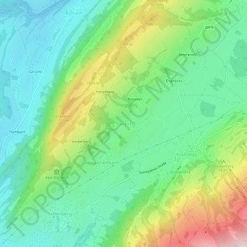
Name: Sterklis topographic map, elevation, terrain.
Average elevation: 898 m
Minimum elevation: 703 m
Maximum elevation: 1,316 m
Other topographic maps
Click on a map to view its topography, its elevation and its terrain.
Grünten
Deutschland > Bayern > Landkreis Oberallgäu > Rettenberg > Wagneritz
Der Grünten gehört in der naturräumlichen Haupteinheitengruppe Nördliche Kalk-Westalpen (Nr. 95) und in der Haupteinheit Vorarlberg-Allgäuer Quintner- und Schrattenkalkgewölbe (950) zum Naturraum Grünten (950.0). Nach Norden leitet die Landschaft in die Untereinheit Rettenberger Tal (024.1) über und…
Average elevation: 1,121 m