Geolocate

Cabrils topographic map

Click on the map to display elevation.

About this map

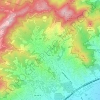
Name: Cabrils topographic map, elevation, terrain.

Location: Cabrils, Maresme, Barcelona, Catalonia, 08348, Spain (41.51245 2.34288 41.54385 2.39169)

Average elevation: 220 m

Minimum elevation: 25 m

Maximum elevation: 478 m

Other topographic maps

Click on a map to view its topography, its elevation and its terrain.

Palafolls

Spain > Catalonia > Maresme > Palafolls > Palafolls

Average elevation: 26 m

el Masnou

Spain > Catalonia > Maresme > el Masnou > el Masnou

Average elevation: 92 m

Gear up for your next adventure:

🧣Merino Neck Gaiter - Protects against wind, sun, and cold at high altitudes
🚲MTB Frame Bag - Carry tools and maps directly on your bicycle frame
🌡️Emergency Mylar Blankets - Compact thermal protection for unexpected nights outdoors
🥾Trail Running Shoes - Lightweight and durable shoes for trail running
💧Reusable Water Bottle - Durable water bottles for hydration on trails

As an Amazon Associate, this site earns from qualifying purchases at no extra cost to you.