
Make a donation
Gear up for your next adventure:
As an Amazon Associate, this site earns from qualifying purchases at no extra cost to you.
Puerto Saavedra topographic map
Click on the map to display elevation.
Make a donation
Gear up for your next adventure:
As an Amazon Associate, this site earns from qualifying purchases at no extra cost to you.
About this map
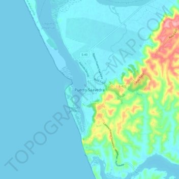
Name: Puerto Saavedra topographic map, elevation, terrain.
Average elevation: 17 m
Minimum elevation: 0 m
Maximum elevation: 127 m
Make a donation
Gear up for your next adventure:
As an Amazon Associate, this site earns from qualifying purchases at no extra cost to you.
Other topographic maps
Click on a map to view its topography, its elevation and its terrain.
Lago Budi
Chile > Región de la Araucanía > Provincia de Cautín > Saavedra
A lo largo de la historia el lago Budi se fue esculpiendo por constantes aumentos de mar y de las mareas; como consecuencia del terremoto de Valdivia de 1960, amplias zonas de baja altitud que eran usadas para la agricultura cercanas a la isla Huapi (que no es propiamente una isla, sino el frente de tierra que…
Average elevation: 9 m