
Hagwilget topographic map
Click on the map to display elevation.
About this map
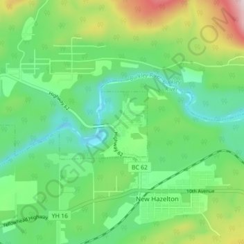
Name: Hagwilget topographic map, elevation, terrain.
Average elevation: 337 m
Minimum elevation: 214 m
Maximum elevation: 613 m
Regional District of Kitimat-Stikine trails, hiking, mountain biking, running and outdoor activities
Other topographic maps
Click on a map to view its topography, its elevation and its terrain.
Swan Lake
Canada > British Columbia > Regional District of Kitimat-Stikine > Area B (Suskwa/Kitwanga/Kispiox)
Average elevation: 540 m
Affleck Lake
Canada > British Columbia > Regional District of Kitimat-Stikine > Area B (Suskwa/Kitwanga/Kispiox)
Average elevation: 417 m
Pentz Lake
Canada > British Columbia > Regional District of Kitimat-Stikine > Area B (Suskwa/Kitwanga/Kispiox)
Average elevation: 356 m