Geolocate

Chuping topographic map

Click on the map to display elevation.

About this map

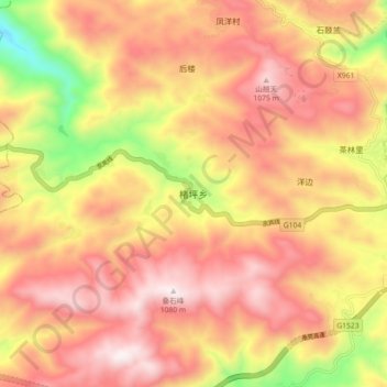
Name: Chuping topographic map, elevation, terrain.

Location: Chuping, Zherong County, Ningde City, Fujian, China (27.19274 119.77555 27.27274 119.85555)

Average elevation: 761 m

Minimum elevation: 209 m

Maximum elevation: 1,120 m

Gear up for your next adventure:

🥤Collapsible Travel Cup - Saves space and weight in your mess kit
💧Collapsible Water Bottle - Space-saving water bottle for outdoor activities
🧥Softshell Jacket - Windproof and breathable jacket for hiking
🔪Outdoor Multitool - Versatile tool for repairs and food prep in the wild
🧢Beanie Hat - Keep your head warm in cold weather

As an Amazon Associate, this site earns from qualifying purchases at no extra cost to you.