Geolocate

Huaron topographic map

Click on the map to display elevation.

About this map

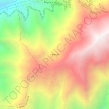
Name: Huaron topographic map, elevation, terrain.

Location: Huaron, Cáceres del Perú, Santa, Áncash, Perú (-8.91044 -78.17028 -8.87044 -78.13028)

Average elevation: 3,019 m

Minimum elevation: 2,009 m

Maximum elevation: 3,834 m

Gear up for your next adventure:

🔭Compact Monocular - One-handed bird watching and trail spotting
🥾Hiking Boots - Sturdy boots providing ankle support and traction on rugged trails
🧢Hiking Hat - Sun-protective and breathable hats for long treks
🥾Mountain Hiking Shoes - Shoes with superior grip for mountainous terrain
🛶Canoe Life Vest - Safety vest for water sports

As an Amazon Associate, this site earns from qualifying purchases at no extra cost to you.