
Thank you for supporting this site ❤️
Make a donation
Make a donation
Gear up for your next adventure:
As an Amazon Associate, this site earns from qualifying purchases at no extra cost to you.
Guablid topographic map
Click on the map to display elevation.
Thank you for supporting this site ❤️
Make a donation
Make a donation
Gear up for your next adventure:
As an Amazon Associate, this site earns from qualifying purchases at no extra cost to you.
About this map
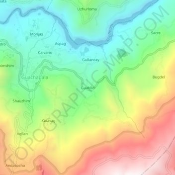
Name: Guablid topographic map, elevation, terrain.
Location: Guablid, Guachapala, Azuay, 010601, Ecuador (-2.79502 -78.72099 -2.75502 -78.68099)
Average elevation: 2,526 m
Minimum elevation: 2,125 m
Maximum elevation: 3,135 m
Thank you for supporting this site ❤️
Make a donation
Make a donation
Gear up for your next adventure:
As an Amazon Associate, this site earns from qualifying purchases at no extra cost to you.