
Make a donation
Gear up for your next adventure:
As an Amazon Associate, this site earns from qualifying purchases at no extra cost to you.
Suttrop topographic map
Click on the map to display elevation.
Make a donation
Gear up for your next adventure:
As an Amazon Associate, this site earns from qualifying purchases at no extra cost to you.
About this map
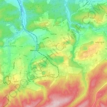
Name: Suttrop topographic map, elevation, terrain.
Location: Suttrop, Warstein, Kreis Soest, Nordrhein-Westfalen, Deutschland (51.40769 8.34158 51.47963 8.40985)
Average elevation: 376 m
Minimum elevation: 255 m
Maximum elevation: 543 m
Make a donation
Gear up for your next adventure:
As an Amazon Associate, this site earns from qualifying purchases at no extra cost to you.
Other topographic maps
Click on a map to view its topography, its elevation and its terrain.
Oberhagen
Deutschland > Nordrhein-Westfalen > Kreis Soest > Warstein > Suttrop
Average elevation: 344 m
Belecke
Deutschland > Nordrhein-Westfalen > Kreis Soest > Warstein
Belecke ist seit 1975 ein Ortsteil der Stadt Warstein im Kreis Soest in Nordrhein-Westfalen (Deutschland). Zum 1. Oktober 2020 hatte er 5386 Einwohner. Der Ort liegt zwischen dem Haarstrang im Norden und dem Sauerland im Süden an der Möhne. Das Zentrum des Orts befindet sich auf einer Höhe von 255 Metern…
Average elevation: 291 m
Make a donation
Gear up for your next adventure:
As an Amazon Associate, this site earns from qualifying purchases at no extra cost to you.