
Make a donation
Gear up for your next adventure:
As an Amazon Associate, this site earns from qualifying purchases at no extra cost to you.
Ilha do Boi topographic map
Click on the map to display elevation.
Make a donation
Gear up for your next adventure:
As an Amazon Associate, this site earns from qualifying purchases at no extra cost to you.
About this map
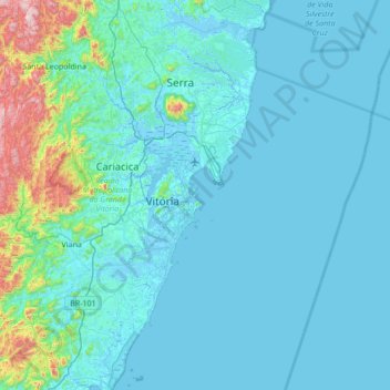
Name: Ilha do Boi topographic map, elevation, terrain.
Average elevation: 93 m
Minimum elevation: -5 m
Maximum elevation: 1,013 m
Make a donation
Gear up for your next adventure:
As an Amazon Associate, this site earns from qualifying purchases at no extra cost to you.
Other topographic maps
Click on a map to view its topography, its elevation and its terrain.
São Benedito
Brasil > Espírito Santo > Região Metropolitana da Grande Vitória > Vitória
Average elevation: 15 m
Boa Vista
Brasil > Espírito Santo > Região Metropolitana da Grande Vitória > Vitória
Average elevation: 3 m
Praia do Canto
Brasil > Espírito Santo > Região Metropolitana da Grande Vitória > Vitória
Average elevation: 9 m
Grande Vitória
Brasil > Espírito Santo > Região Metropolitana da Grande Vitória > Vitória
Average elevation: 40 m
Make a donation
Gear up for your next adventure:
As an Amazon Associate, this site earns from qualifying purchases at no extra cost to you.
Santo Antônio
Brasil > Espírito Santo > Região Metropolitana da Grande Vitória > Vitória
Average elevation: 28 m
Pontal de Camburi
Brasil > Espírito Santo > Região Metropolitana da Grande Vitória > Vitória
Average elevation: 8 m
Goiabeiras
Brasil > Espírito Santo > Região Metropolitana da Grande Vitória > Vitória
Average elevation: 3 m
Vila Rubim
Brasil > Espírito Santo > Região Metropolitana da Grande Vitória > Vitória
Average elevation: 42 m
Make a donation
Gear up for your next adventure:
As an Amazon Associate, this site earns from qualifying purchases at no extra cost to you.
Vitória
Brasil > Espírito Santo > Região Metropolitana da Grande Vitória > Vitória
Average elevation: 18 m
Jardim Camburi
Brasil > Espírito Santo > Região Metropolitana da Grande Vitória > Vitória
Average elevation: 9 m
Baía do Espírito Santo
Brasil > Espírito Santo > Região Metropolitana da Grande Vitória > Vitória
Average elevation: 2 m
Parque Estadual da Fonte Grande
Brasil > Espírito Santo > Região Metropolitana da Grande Vitória > Vitória
O parque é a última área contígua de grande porte com vegetação característica de encostas da Mata Atlântica. A topografia é acidentada, com relevo ondulado, incluindo vales e pontões.
Average elevation: 91 m
Make a donation
Gear up for your next adventure:
As an Amazon Associate, this site earns from qualifying purchases at no extra cost to you.
Praia de Camburi
Brasil > Espírito Santo > Região Metropolitana da Grande Vitória > Vitória
Average elevation: 4 m
República
Brasil > Espírito Santo > Região Metropolitana da Grande Vitória > Vitória
Average elevation: 3 m
Barro Vermelho
Brasil > Espírito Santo > Região Metropolitana da Grande Vitória > Vitória
Average elevation: 11 m
Santa Tereza
Brasil > Espírito Santo > Região Metropolitana da Grande Vitória > Vitória
Average elevation: 53 m
Make a donation
Gear up for your next adventure:
As an Amazon Associate, this site earns from qualifying purchases at no extra cost to you.
Ilha do Frade
Brasil > Espírito Santo > Região Metropolitana da Grande Vitória > Vitória
Average elevation: 3 m
Praça do Papa
Brasil > Espírito Santo > Região Metropolitana da Grande Vitória > Vitória
Average elevation: 11 m
Ilha das Caieiras
Brasil > Espírito Santo > Região Metropolitana da Grande Vitória > Vitória
Average elevation: 19 m
Fonte Grande
Brasil > Espírito Santo > Região Metropolitana da Grande Vitória > Vitória
Average elevation: 72 m
Make a donation
Gear up for your next adventure:
As an Amazon Associate, this site earns from qualifying purchases at no extra cost to you.