Geolocate

Kipipiri topographic map

Click on the map to display elevation.

About this map

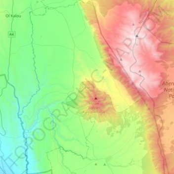
Name: Kipipiri topographic map, elevation, terrain.

Location: Kipipiri, Nyandarua, Central Kenya, 20301, Kenya (-0.57507 36.38777 -0.23726 36.62977)

Average elevation: 2,669 m

Minimum elevation: 1,929 m

Maximum elevation: 3,997 m

Other topographic maps

Click on a map to view its topography, its elevation and its terrain.

Mount Satima

Kenya > Nyandarua

Average elevation: 3,805 m

Gear up for your next adventure:

🧥Waterproof Pants - Keep dry during rainy hiking conditions
🎒Fully Waterproof Backpack - Total protection for photography gear and electronics
🥤Collapsible Travel Cup - Saves space and weight in your mess kit
🥾Light Hiking Boots - Lightweight and comfortable boots for day hikes
🧥Softshell Hiking Jacket - The perfect balance of wind protection and breathability

As an Amazon Associate, this site earns from qualifying purchases at no extra cost to you.