
Make a donation
Gear up for your next adventure:
As an Amazon Associate, this site earns from qualifying purchases at no extra cost to you.
Corullón topographic map
Click on the map to display elevation.
Make a donation
Gear up for your next adventure:
As an Amazon Associate, this site earns from qualifying purchases at no extra cost to you.
About this map
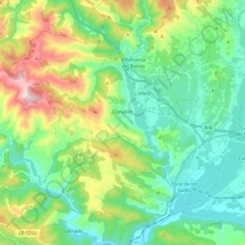
Name: Corullón topographic map, elevation, terrain.
Location: Corullón, El Bierzo, León, Castilië en León, Spanje (42.52827 -6.94633 42.62170 -6.77711)
Average elevation: 642 m
Minimum elevation: 397 m
Maximum elevation: 1,267 m
Make a donation
Gear up for your next adventure:
As an Amazon Associate, this site earns from qualifying purchases at no extra cost to you.
Other topographic maps
Click on a map to view its topography, its elevation and its terrain.
El Puente de Domingo Flórez / A Ponte
Spanje > Castilië en León > El Bierzo > Puente de Domingo Flórez
Average elevation: 527 m
Make a donation
Gear up for your next adventure:
As an Amazon Associate, this site earns from qualifying purchases at no extra cost to you.
San Fiz do Seo
Spanje > Castilië en León > El Bierzo > Trabadelo > San Fiz do Seo
Average elevation: 782 m