Geolocate

Recas topographic map

Click on the map to display elevation.

About this map

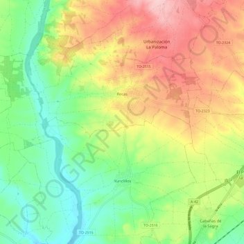
Name: Recas topographic map, elevation, terrain.

Location: Recas, Toledo, Castile-La Mancha, 45211, Spain (40.00152 -4.06916 40.08412 -3.95245)

Average elevation: 555 m

Minimum elevation: 480 m

Maximum elevation: 652 m

Gear up for your next adventure:

🧢Outdoor Cap - Protective cap for sun and rain during hikes
🧴Waterproofing Spray - Restore the DWR coating on jackets and tents
🔦LED Headtorch - Bright and durable light for night activities
📷Outdoor Action Camera - Capture high-elevation views and rugged adventures
🥾Trail Running Boots - Durable shoes designed for trail running

As an Amazon Associate, this site earns from qualifying purchases at no extra cost to you.