
Te Awamutu topographic map
Click on the map to display elevation.
About this map
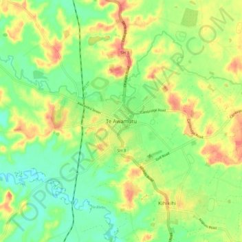
Name: Te Awamutu topographic map, elevation, terrain.
Location: Te Awamutu, Waipa District, Waikato, 3800, New Zealand (-38.05016 175.28578 -37.97016 175.36578)
Average elevation: 57 m
Minimum elevation: 25 m
Maximum elevation: 99 m
Other topographic maps
Click on a map to view its topography, its elevation and its terrain.
Rangiaowhia War Memorial Domain
New Zealand > Waikato > Waipa District > Kihikihi > Rangiaowhia
Average elevation: 69 m