Geolocate

Hamidpur topographic map

Click on the map to display elevation.

About this map

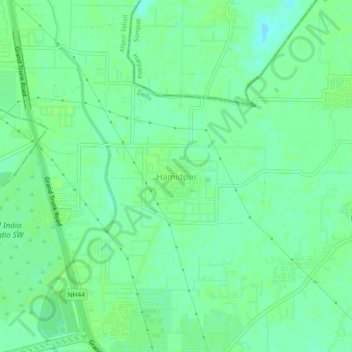
Name: Hamidpur topographic map, elevation, terrain.

Location: Hamidpur, Alipur Tehsil, North Delhi, Delhi, 110036, India (28.80884 77.12778 28.84884 77.16778)

Average elevation: 211 m

Minimum elevation: 205 m

Maximum elevation: 214 m

Other topographic maps

Click on a map to view its topography, its elevation and its terrain.

Sector 12

India > Delhi > Alipur Tehsil

Average elevation: 218 m

Sector 15

India > Delhi > Alipur Tehsil

Average elevation: 217 m

Gear up for your next adventure:

🥾Approach Boots - Comfortable boots for hiking and climbing approaches
🕯️Camping Lantern - Illuminates your entire campsite with high-efficiency LEDs
🥾Hiking Gaiters - Protect legs and shoes from mud, snow, and debris
🔥Emergency Fire Starter - Reliable ignition source for all weather conditions
Backpacking Tent - Lightweight tent for long-distance hiking trips

As an Amazon Associate, this site earns from qualifying purchases at no extra cost to you.