
Mosinee topographic map
Click on the map to display elevation.
About this map
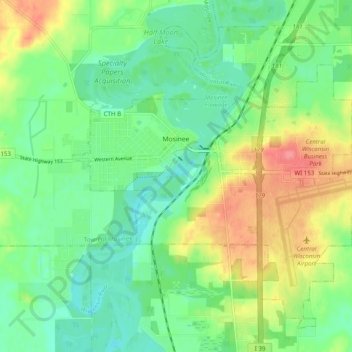
Name: Mosinee topographic map, elevation, terrain.
Location: Mosinee, Marathon County, Wisconsin, 54455, United States (44.75522 -89.73242 44.81537 -89.63435)
Average elevation: 357 m
Minimum elevation: 331 m
Maximum elevation: 403 m
Other topographic maps
Click on a map to view its topography, its elevation and its terrain.
George W Mead State Wildlife Management Area
United States > Wisconsin > Marathon County > Town of Bergen
Average elevation: 343 m
Bypass Channel Wisconsin River
United States > Wisconsin > Marathon County > Wausau
Average elevation: 371 m