Schefferville topographic map
Click on the map to display elevation.
Schefferville
The cold winters are caused in part by elevation, and in part the ice cover of Hudson Bay eliminating maritime moderation in winter. Although Schefferville is nearer the Atlantic, the cold Labrador Current brings cold air also from the east. In summer, the Hudson Bay water is cold after just thawing, and the Labrador waters remains cool and prone to low-pressure systems under the Icelandic Low. As a result, even the vast landmass seldom builds up heat and remains extremely chilly for the latitude. Areas on similar or higher latitudes in western Canada are much warmer also in this time of the year as a result. The low mean annual air temperature of -5.3 °C (22.5 °F) indicates widespread occurrences of permafrost.
About this map
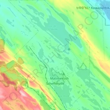
Name: Schefferville topographic map, elevation, terrain.
Average elevation: 537 m
Minimum elevation: 476 m
Maximum elevation: 699 m
Caniapiscau (MRC) trails, hiking, mountain biking, running and outdoor activities
Other topographic maps
Click on a map to view its topography, its elevation and its terrain.