Geolocate

Energy topographic map

Click on the map to display elevation.

About this map

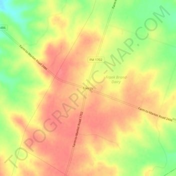
Name: Energy topographic map, elevation, terrain.

Location: Energy, Comanche County, Texas, 76452, United States (31.74302 -98.38891 31.78302 -98.34891)

Average elevation: 424 m

Minimum elevation: 385 m

Maximum elevation: 446 m

Gear up for your next adventure:

🕶️Polarized Sunglasses - Protect your eyes with durable polarized lenses
🚲Handlebar Phone Mount - View topographic-map.com live while cycling
🔋Emergency Crank Radio - Weather alerts and power without needing batteries
🚲MTB Frame Bag - Carry tools and maps directly on your bicycle frame
🛏️Sleeping Bag - Warm and compact sleeping bags for outdoor camping

As an Amazon Associate, this site earns from qualifying purchases at no extra cost to you.