
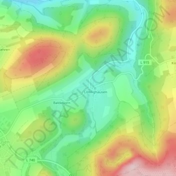
Löllinghausen topographic map
Interactive map
Click on the map to display elevation.
About this map
Name: Löllinghausen topographic map, elevation, terrain.
Average elevation: 410 m
Minimum elevation: 290 m
Maximum elevation: 584 m
Other topographic maps
Click on a map to view its topography, its elevation and its terrain.
Bonacker
Duitsland > Noordrijn-Westfalen > Hochsauerlandkreis > Meschede
Bonacker, Meschede, Hochsauerlandkreis, Noordrijn-Westfalen, Duitsland
Average elevation: 521 m
Hennesee
Duitsland > Noordrijn-Westfalen > Hochsauerlandkreis > Meschede > Berghausen
Hennesee, Berghausen, Meschede, Hochsauerlandkreis, Noordrijn-Westfalen, Duitsland
Average elevation: 381 m
Grevenstein
Duitsland > Noordrijn-Westfalen > Hochsauerlandkreis > Meschede
Grevenstein, Meschede, Hochsauerlandkreis, Noordrijn-Westfalen, Duitsland
Average elevation: 417 m