Geolocate

Trapani topographic map

Click on the map to display elevation.

About this map
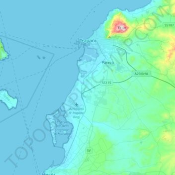
Name: Trapani topographic map, elevation, terrain.

Location: Trapani, Sicily, 91100, Italy (37.83681 12.43849 38.04349 12.80085)

Average elevation: 219 m

Minimum elevation: -1 m

Maximum elevation: 1,100 m

Other topographic maps

Click on a map to view its topography, its elevation and its terrain.

Isola San Pantaleo

Italy > Sicily > Trapani > Marsala

Average elevation: 1 m

Scopello

Italy > Sicily > Trapani > Castellammare del Golfo

Average elevation: 150 m

Segesta

Italy > Sicily > Trapani > Calatafimi Segesta

Average elevation: 269 m

Trapani

Italy > Sicily > Trapani > Trapani

Average elevation: 46 m

Nubia

Italy > Sicily > Trapani > Paceco

Average elevation: 4 m

Mursía

Italy > Sicily > Trapani > Pantelleria

Average elevation: 40 m

Macari

Italy > Sicily > Trapani

Average elevation: 225 m

Isola San Pantaleo

Italy > Sicily > Trapani > Marsala

Average elevation: 1 m

Nubia

Italy > Sicily > Trapani > Paceco

Average elevation: 4 m

Monte Casal Monaco

Italy > Sicily > Trapani > Trapani

Average elevation: 453 m

Gear up for your next adventure:

🥾Durable Hiking Shoes - Long-lasting shoes for frequent hiking
💧Filtered Water Bottle - Safe drinking water on the go
🧥Thermal Layer - Insulating layer for cold outdoor conditions
🥾Trekking Boots - Durable boots for long-distance trekking
🥾Trail Hiking Shoes - Durable shoes designed for rugged trails

As an Amazon Associate, this site earns from qualifying purchases at no extra cost to you.