Geolocate

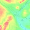
Fall Lake Township topographic map

Click on the map to display elevation.

About this map

Name: Fall Lake Township topographic map, elevation, terrain.

Location: Fall Lake Township, Lake County, Minnesota, United States (47.80211 -91.80141 48.20600 -91.02584)

Average elevation: 455 m

Minimum elevation: 375 m

Maximum elevation: 611 m

Other topographic maps

Click on a map to view its topography, its elevation and its terrain.

London

United States > Minnesota > Lake County

Average elevation: 406 m

Castle Danger

United States > Minnesota > Lake County

Average elevation: 212 m

Hum Lake

United States > Minnesota > Lake County

Average elevation: 468 m

Gear up for your next adventure:

🎒Hiking Backpack - Lightweight and ergonomic backpacks for day hikes or multi-day treks
🥾Lightweight Hiking Shoes - Comfortable shoes for day hikes
🔭Outdoor Binoculars - Lightweight binoculars for birdwatching and hiking
🛶Waterproof Dry Bags - Keep electronics and clothes dry during river crossings
🧤Thermal Hiking Gloves - Grip-enhanced gloves for cold-weather altitude trekking

As an Amazon Associate, this site earns from qualifying purchases at no extra cost to you.