Geolocate

Cuchara topographic map

Click on the map to display elevation.

About this map

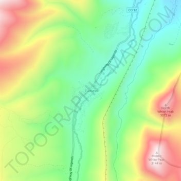
Name: Cuchara topographic map, elevation, terrain.

Location: Cuchara, Huerfano County, Colorado, United States (37.35924 -105.12029 37.39924 -105.08029)

Average elevation: 2,744 m

Minimum elevation: 2,477 m

Maximum elevation: 3,143 m

Other topographic maps

Click on a map to view its topography, its elevation and its terrain.

Walsenburg

United States > Colorado > Huerfano County

Average elevation: 1,899 m

La Veta

United States > Colorado > Huerfano County

Average elevation: 2,157 m

La Veta

United States > Colorado > Huerfano County

Average elevation: 2,157 m

La Veta

United States > Colorado > Huerfano County

Average elevation: 2,157 m

Bear Lake

United States > Colorado > Huerfano County

Average elevation: 3,277 m

Gear up for your next adventure:

🚲Handlebar Phone Mount - View topographic-map.com live while cycling
🐕Hiking Dog Pack - Let your canine companion carry their own water and food
🔦LED Flashlight - Powerful and long-lasting flashlight for camping and emergencies
🔥Camping Stove - Portable stoves to cook outdoors with ease
🥽Outdoor Goggles - Protective eyewear for outdoor activities

As an Amazon Associate, this site earns from qualifying purchases at no extra cost to you.