
Make a donation
Gear up for your next adventure:
As an Amazon Associate, this site earns from qualifying purchases at no extra cost to you.
Deira topographic map
Click on the map to display elevation.
Make a donation
Gear up for your next adventure:
As an Amazon Associate, this site earns from qualifying purchases at no extra cost to you.
About this map
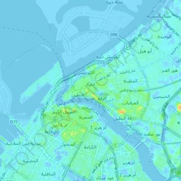
Name: Deira topographic map, elevation, terrain.
Location: Deira, Dubai, United Arab Emirates (25.23468 55.29213 25.30557 55.36026)
Average elevation: 3 m
Minimum elevation: -15 m
Maximum elevation: 28 m
Make a donation
Gear up for your next adventure:
As an Amazon Associate, this site earns from qualifying purchases at no extra cost to you.
Other topographic maps
Click on a map to view its topography, its elevation and its terrain.
Hatta
Due to Hatta's higher altitude, its climate is much cooler than central Dubai. Hatta has an arid landscape and temperature, reaching 55 degrees Celsius in the summer; however, it is less humid than Dubai and far colder in the winter.
Average elevation: 431 m