
Make a donation
Gear up for your next adventure:
As an Amazon Associate, this site earns from qualifying purchases at no extra cost to you.
Malone topographic map
Click on the map to display elevation.
Make a donation
Gear up for your next adventure:
As an Amazon Associate, this site earns from qualifying purchases at no extra cost to you.
About this map
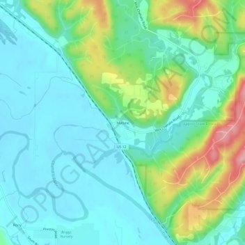
Name: Malone topographic map, elevation, terrain.
Average elevation: 44 m
Minimum elevation: 5 m
Maximum elevation: 160 m
Make a donation
Gear up for your next adventure:
As an Amazon Associate, this site earns from qualifying purchases at no extra cost to you.
Other topographic maps
Click on a map to view its topography, its elevation and its terrain.
Ocean Shores
United States > Washington > Grays Harbor County
Ocean Shores is set on relatively flat coastal terrain. The city's elevation averages about 10 to 15 feet (3 to 5 meters) above sea level, typical for much of the Washington coast's beach communities. It sits on a spit of land between the Pacific Ocean to the west and Grays Harbor to the east. This unique…
Average elevation: 1 m
Aberdeen
United States > Washington > Grays Harbor County
Aberdeen is at the eastern end of Grays Harbor, near the mouth of the Chehalis River and southwest of the Olympic Mountains. Grays Harbor is notable as the northernmost ria on North America's Pacific Coast because it has remained free of glaciers throughout the Quaternary due to unfavorable topography and warm…
Average elevation: 48 m
Make a donation
Gear up for your next adventure:
As an Amazon Associate, this site earns from qualifying purchases at no extra cost to you.
Make a donation
Gear up for your next adventure:
As an Amazon Associate, this site earns from qualifying purchases at no extra cost to you.
Copalis Beach
United States > Washington > Grays Harbor County > Copalis Beach
Average elevation: 13 m
Roosevelt Beach Conservation Area
United States > Washington > Grays Harbor County > Ocean Grove
Average elevation: 18 m
Make a donation
Gear up for your next adventure:
As an Amazon Associate, this site earns from qualifying purchases at no extra cost to you.
Ocean Shores
United States > Washington > Grays Harbor County
The Point Brown Peninsula is entirely occupied by Ocean Shores and portions of Oyehut. It is 6,000 acres (2,400 ha) in area, and acts as a breakwater to the entrance of Grays Harbor, the estuary of the Chehalis River. Similar to the Long Beach Peninsula, the Point Brown Peninsula is at high risk of destruction…
Average elevation: 1 m
Copalis Beach
United States > Washington > Grays Harbor County > Copalis Beach
Average elevation: 13 m
Make a donation
Gear up for your next adventure:
As an Amazon Associate, this site earns from qualifying purchases at no extra cost to you.
Aberdeen
United States > Washington > Grays Harbor County
Aberdeen is at the eastern end of Grays Harbor, near the mouth of the Chehalis River and southwest of the Olympic Mountains. Grays Harbor is notable as the northernmost ria on North America's Pacific Coast because it has remained free of glaciers throughout the Quaternary due to unfavorable topography and warm…
Average elevation: 48 m
Make a donation
Gear up for your next adventure:
As an Amazon Associate, this site earns from qualifying purchases at no extra cost to you.
Make a donation
Gear up for your next adventure:
As an Amazon Associate, this site earns from qualifying purchases at no extra cost to you.
Roosevelt Beach Conservation Area
United States > Washington > Grays Harbor County > Ocean Grove
Average elevation: 18 m