
Make a donation
Gear up for your next adventure:
As an Amazon Associate, this site earns from qualifying purchases at no extra cost to you.
Debabarrena topographic map
Click on the map to display elevation.
Make a donation
Gear up for your next adventure:
As an Amazon Associate, this site earns from qualifying purchases at no extra cost to you.
About this map
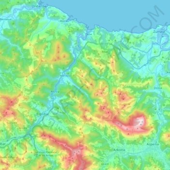
Name: Debabarrena topographic map, elevation, terrain.
Location: Debabarrena, Guipuscoa, Pays basque autonome, Espagne (43.16179 -2.49966 43.32426 -2.26601)
Average elevation: 254 m
Minimum elevation: -2 m
Maximum elevation: 1,011 m
Make a donation
Gear up for your next adventure:
As an Amazon Associate, this site earns from qualifying purchases at no extra cost to you.
Other topographic maps
Click on a map to view its topography, its elevation and its terrain.
Biaritz
Espagne > Pays basque autonome > Arabako lautada > Agurain / Salvatierra
Average elevation: 599 m
Make a donation
Gear up for your next adventure:
As an Amazon Associate, this site earns from qualifying purchases at no extra cost to you.
Cascada de las Ollerías / Ollerias ur-jauzia
Espagne > Pays basque autonome > Montagne Alavaise > Peñacerrada-Urizaharra
Average elevation: 806 m
Antoñana
Espagne > Pays basque autonome > Montagne Alavaise > Campezo / Kanpezu
Average elevation: 702 m
Make a donation
Gear up for your next adventure:
As an Amazon Associate, this site earns from qualifying purchases at no extra cost to you.
Make a donation
Gear up for your next adventure:
As an Amazon Associate, this site earns from qualifying purchases at no extra cost to you.
Elurtzuloeta
Espagne > Pays basque autonome > Arabako lautada/Llanada Alavesa
Average elevation: 1,062 m
42
Espagne > Pays basque autonome > Basse-Bidassoa > Irun > Endarlatsa etxetxoa
Average elevation: 232 m
Make a donation
Gear up for your next adventure:
As an Amazon Associate, this site earns from qualifying purchases at no extra cost to you.
Ziortza-Bolibar
Espagne > Pays basque autonome > Ziortza-Bolibar > Ziortza-Bolibar
Average elevation: 303 m
Make a donation
Gear up for your next adventure:
As an Amazon Associate, this site earns from qualifying purchases at no extra cost to you.
Gautegiz Arteaga
Espagne > Pays basque autonome > Gautegiz Arteaga > Gautegiz Arteaga
Average elevation: 104 m
El Mazo
Espagne > Pays basque autonome > Karrantza Harana / Valle de Carranza
Average elevation: 546 m
Alegría-Dulantzi
Espagne > Pays basque autonome > Arabako lautada/Llanada Alavesa > Alegría-Dulantzi
Average elevation: 582 m
Make a donation
Gear up for your next adventure:
As an Amazon Associate, this site earns from qualifying purchases at no extra cost to you.
Amute-Kosta
Espagne > Pays basque autonome > Basse-Bidassoa > Hondarribia > Amute-Kosta
Average elevation: 27 m
Caranca
Espagne > Pays basque autonome > Añanako kuadrilla/Cuadrilla de Añana
Average elevation: 689 m
Make a donation
Gear up for your next adventure:
As an Amazon Associate, this site earns from qualifying purchases at no extra cost to you.