
Roquetes topographic map
Interactive map
Click on the map to display elevation.
About this map
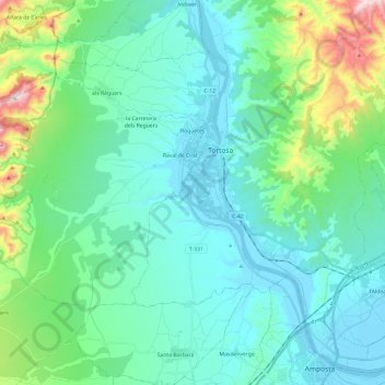
Name: Roquetes topographic map, elevation, terrain.
Location: Roquetes, Baix Ebre, Tarragona, Catalonië, 43520, Spanje (40.73635 0.27073 40.84562 0.51044)
Average elevation: 142 m
Minimum elevation: -2 m
Maximum elevation: 772 m
Other topographic maps
Click on a map to view its topography, its elevation and its terrain.
l'Ametlla de Mar
Spanje > Catalonië > Baix Ebre
l'Ametlla de Mar, Baix Ebre, Tarragona, Catalonië, 43860, Spanje
Average elevation: 62 m
Benifallet
Spanje > Catalonië > Baix Ebre
Benifallet, Baix Ebre, Tarragona, Catalonië, 43512, Spanje
Average elevation: 230 m