
Make a donation
Gear up for your next adventure:
As an Amazon Associate, this site earns from qualifying purchases at no extra cost to you.
Athens topographic map
Click on the map to display elevation.
Make a donation
Gear up for your next adventure:
As an Amazon Associate, this site earns from qualifying purchases at no extra cost to you.
Athens
The Cherokee were living in McMinn County at the time of the arrival of the first Euro-American explorers. The Athens area was situated nearly halfway between the Overhill Cherokee villages of Great Tellico to the north in Monroe County and Great Hiwassee along the Hiwassee River to the south. In 1819, the Cherokee signed the Calhoun Treaty, selling the land north of the Hiwassee (including all of modern McMinn County) to the United States. McMinn County was organized on November 13, 1819, at the home of John Walker in what is now Calhoun. The Native American village, Pumpkintown (a corruption of Potemkin town), was located on a farm about two miles east of present-day Athens. It is sometimes incorrectly identified as a forerunner of Athens. Athens was laid out and chosen as the county seat in 1822. The name "Athens" may have been chosen due to perceived topographical similarities to Athens, Greece.
Make a donation
Gear up for your next adventure:
As an Amazon Associate, this site earns from qualifying purchases at no extra cost to you.
About this map
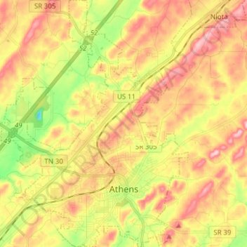
Name: Athens topographic map, elevation, terrain.
Average elevation: 291 m
Minimum elevation: 196 m
Maximum elevation: 372 m
Make a donation
Gear up for your next adventure:
As an Amazon Associate, this site earns from qualifying purchases at no extra cost to you.
Other topographic maps
Click on a map to view its topography, its elevation and its terrain.
Athens
United States > Tennessee > McMinn County > Athens
The Cherokee were living in McMinn County at the time of the arrival of the first Euro-American explorers. The Athens area was situated nearly halfway between the Overhill Cherokee villages of Great Tellico to the north in Monroe County and Great Hiwassee along the Hiwassee River to the south. In 1819, the…
Average elevation: 287 m
Make a donation
Gear up for your next adventure:
As an Amazon Associate, this site earns from qualifying purchases at no extra cost to you.
Make a donation
Gear up for your next adventure:
As an Amazon Associate, this site earns from qualifying purchases at no extra cost to you.