
Thank you for supporting this site ❤️
Make a donation
Make a donation
Gear up for your next adventure:
As an Amazon Associate, this site earns from qualifying purchases at no extra cost to you.
Ermida topographic map
Click on the map to display elevation.
Thank you for supporting this site ❤️
Make a donation
Make a donation
Gear up for your next adventure:
As an Amazon Associate, this site earns from qualifying purchases at no extra cost to you.
About this map
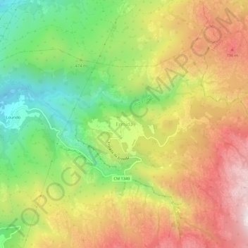
Name: Ermida topographic map, elevation, terrain.
Location: Ermida, Ponte da Barca, Viana do Castelo, 4980-213, Portugal (41.80038 -8.27833 41.84038 -8.23833)
Average elevation: 530 m
Minimum elevation: 111 m
Maximum elevation: 967 m
Thank you for supporting this site ❤️
Make a donation
Make a donation
Gear up for your next adventure:
As an Amazon Associate, this site earns from qualifying purchases at no extra cost to you.
Other topographic maps
Click on a map to view its topography, its elevation and its terrain.
Ponte da Barca, Vila Nova de Muía e Paço Vedro de Magalhães
Portugal > Viana do Castelo > Ponte da Barca
Average elevation: 127 m