Geolocate

Sabang topographic map

Click on the map to display elevation.

About this map

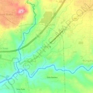
Name: Sabang topographic map, elevation, terrain.

Location: Sabang, Ibaan, Batangas, Calabarzon, 4230, Philippines (13.77940 121.08868 13.81940 121.12868)

Average elevation: 80 m

Minimum elevation: 9 m

Maximum elevation: 180 m

Other topographic maps

Click on a map to view its topography, its elevation and its terrain.

Pangao

Philippines > Batangas > Ibaan

Average elevation: 130 m

Calumpang River

Philippines > Batangas > Ibaan > Catandala

Average elevation: 93 m

Calumpang River

Philippines > Batangas > Ibaan > Balanga

Average elevation: 84 m

Calumpang River

Philippines > Batangas > Ibaan

Average elevation: 99 m

Coliat

Philippines > Batangas > Ibaan

Average elevation: 113 m

Talaibon

Philippines > Batangas > Ibaan

Average elevation: 142 m

Pangao

Philippines > Batangas > Ibaan

Average elevation: 130 m

Taysan River

Philippines > Batangas > Ibaan > Salaban Ⅱ

Average elevation: 139 m

Palindan

Philippines > Batangas > Ibaan

Average elevation: 134 m

Balanga

Philippines > Batangas > Ibaan

Average elevation: 93 m

Gear up for your next adventure:

🔦UV Flashlight - Detect minerals or specific insects in the dark
Family Camping Tent - Spacious tent suitable for family camping trips
🥾All-Terrain Hiking Boots - Versatile boots for varied hiking conditions
🚲MTB Frame Bag - Carry tools and maps directly on your bicycle frame
Camping Tent - Weather-resistant tents suitable for 2 to 6 people

As an Amazon Associate, this site earns from qualifying purchases at no extra cost to you.