Geolocate

Pitayó topographic map

Click on the map to display elevation.

About this map

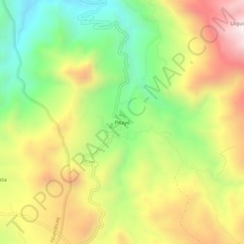
Name: Pitayó topographic map, elevation, terrain.

Location: Pitayó, Silvia, Centro, Cauca, RAP Pacífico, Colombia (2.69448 -76.34400 2.73448 -76.30400)

Average elevation: 2,898 m

Minimum elevation: 2,480 m

Maximum elevation: 3,380 m

Other topographic maps

Click on a map to view its topography, its elevation and its terrain.

QUIZGO

Colombia > Cauca > Silvia

Average elevation: 2,803 m

Gear up for your next adventure:

🦯Trekking Poles - Reduced impact on joints for steep topographic climbs
🧦Merino Wool Socks - Moisture-wicking comfort for long-distance hiking
🥾Hiking Leggings - Comfortable leggings for outdoor activities
🚲Bike Repair Kit - Essential tools for on-trail mechanical issues
💧Collapsible Water Bottle - Space-saving water bottle for outdoor activities

As an Amazon Associate, this site earns from qualifying purchases at no extra cost to you.