
Make a donation
Gear up for your next adventure:
As an Amazon Associate, this site earns from qualifying purchases at no extra cost to you.
Alange topographic map
Click on the map to display elevation.
Make a donation
Gear up for your next adventure:
As an Amazon Associate, this site earns from qualifying purchases at no extra cost to you.
About this map
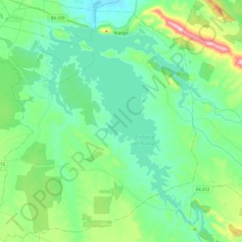
Name: Alange topographic map, elevation, terrain.
Location: Alange, Badajoz, Extremadura, Spain (38.65321 -6.35745 38.80559 -6.18573)
Average elevation: 318 m
Minimum elevation: 219 m
Maximum elevation: 647 m
Make a donation
Gear up for your next adventure:
As an Amazon Associate, this site earns from qualifying purchases at no extra cost to you.
Other topographic maps
Click on a map to view its topography, its elevation and its terrain.
Madrigal de la Vera
Spain > Extremadura > La Vera > Madrigal de la Vera > Madrigal de la Vera
Average elevation: 400 m
Make a donation
Gear up for your next adventure:
As an Amazon Associate, this site earns from qualifying purchases at no extra cost to you.