Geolocate

Rongai topographic map

Click on the map to display elevation.

About this map

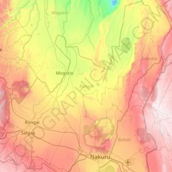
Name: Rongai topographic map, elevation, terrain.

Location: Rongai, Nakuru East, Nakuru, Rift Valley, Kenya (-0.32708 35.78611 0.20146 36.24127)

Average elevation: 1,902 m

Minimum elevation: 986 m

Maximum elevation: 2,863 m

Other topographic maps

Click on a map to view its topography, its elevation and its terrain.

Kenya

Kenya > Nakuru > Nakuru East > Nakuru East ward

Average elevation: 1,831 m

Wild Fire

Kenya > Nakuru > Naivasha > Hells Gate ward > Junction 1

Average elevation: 1,952 m

Fire

Kenya > Nakuru

Average elevation: 1,832 m

Mai Maihu

Kenya > Nakuru

Average elevation: 1,868 m

Gear up for your next adventure:

🧦Crew Hiking Socks - Comfortable socks for long-distance hikes
💡Compact LED Flashlight - Powerful and portable flashlight for outdoor use
🧣Evaporative Cooling Towel - Beat the heat during intense summer climbs
🚲Bike Repair Kit - Essential tools for on-trail mechanical issues
🧥Ultralight Puffy Jacket - Maximum warmth that packs down to the size of an orange

As an Amazon Associate, this site earns from qualifying purchases at no extra cost to you.