Geolocate

Santa Barbara topographic map

Click on the map to display elevation.

About this map

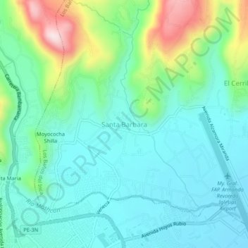
Name: Santa Barbara topographic map, elevation, terrain.

Location: Santa Barbara, Los Baños del Inca, Cajamarca, 06000, Perú (-7.15015 -78.52663 -7.11015 -78.48663)

Average elevation: 2,768 m

Minimum elevation: 2,670 m

Maximum elevation: 3,071 m

Other topographic maps

Click on a map to view its topography, its elevation and its terrain.

Río Chonta

Perú > Cajamarca > Los Baños del Inca

Average elevation: 3,082 m

Gear up for your next adventure:

Camping Tent - Weather-resistant tents suitable for 2 to 6 people
🕯️Camping Lantern - Illuminates your entire campsite with high-efficiency LEDs
🧴Insect Repellent - Protect yourself from bugs during outdoor adventures
💧Filtered Water Bottle - Safe drinking water on the go
🧤Thermal Hiking Gloves - Grip-enhanced gloves for cold-weather altitude trekking

As an Amazon Associate, this site earns from qualifying purchases at no extra cost to you.