
Make a donation
Gear up for your next adventure:
As an Amazon Associate, this site earns from qualifying purchases at no extra cost to you.
Waitsburg topographic map
Click on the map to display elevation.
Make a donation
Gear up for your next adventure:
As an Amazon Associate, this site earns from qualifying purchases at no extra cost to you.
About this map
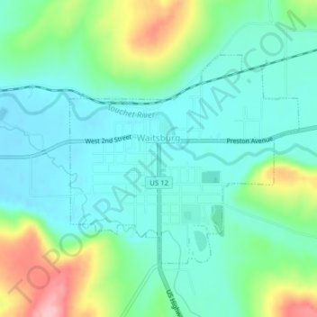
Name: Waitsburg topographic map, elevation, terrain.
Location: Waitsburg, Walla Walla County, Washington, United States (46.25971 -118.16424 46.27746 -118.13595)
Average elevation: 414 m
Minimum elevation: 372 m
Maximum elevation: 528 m
Make a donation
Gear up for your next adventure:
As an Amazon Associate, this site earns from qualifying purchases at no extra cost to you.
Other topographic maps
Click on a map to view its topography, its elevation and its terrain.
Whitman Mission National Historic Site
United States > Washington > Walla Walla County
Average elevation: 196 m
Make a donation
Gear up for your next adventure:
As an Amazon Associate, this site earns from qualifying purchases at no extra cost to you.