
Make a donation
Gear up for your next adventure:
As an Amazon Associate, this site earns from qualifying purchases at no extra cost to you.
Kapsi topographic map
Click on the map to display elevation.
Make a donation
Gear up for your next adventure:
As an Amazon Associate, this site earns from qualifying purchases at no extra cost to you.
Kapsi
Geographically, it lies in the northern lowlands of the Bastar plateau and is a part of the historical Dandakaranya region. The elevation of the village ranges from 310 m (1,020 ft) to 330 m (1,080 ft) above sea level. The Devda ravine, a tributary of Kotri river, meanders through the heart of the village and serves as its lifeline. The region primarily features fertile lateritic soil, which is well-suited to agriculture due to its fine texture and darker hues. With its dense green cover, undulating terrain, hillocks, and stream courses, the region harbours habitats for diverse flora and fauna.
Make a donation
Gear up for your next adventure:
As an Amazon Associate, this site earns from qualifying purchases at no extra cost to you.
About this map
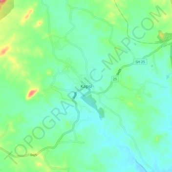
Name: Kapsi topographic map, elevation, terrain.
Average elevation: 325 m
Minimum elevation: 301 m
Maximum elevation: 399 m
Make a donation
Gear up for your next adventure:
As an Amazon Associate, this site earns from qualifying purchases at no extra cost to you.